Glen Canyon Dam Overlook
From US 89, west 1.5 miles from the Carl Hayden Visitor Center, is a Scenic View Drive; There is a parking lot at the end of the drive. From here, a 150 m long handrail path leads down the rocks to a lookout point over the Colorado River.
Horseshoe Bend View
About five miles south of the Carl Hayden Visitor Center on US 89, south of Marker 545, an unpaved road leads west into the hills to a parking lot. After about 650 meters on a sandy path you reach the viewpoint. Here the Colorado River makes a great horseshoe-shaped turn.
Wiregrass Canyon
The Wiregrass Canyon can only be reached after a long, strenuous hike. From Page, take US 89 north towards Big Water, Utah. Turn right between highway markers 7 and 8 (direction sign “Big Water City”). After about 500 m (direction sign “Glen Canyon National Recreation Area – State Highway 12) about 7.5 km further to the parking lot of the Wiregrass Canyon Back Country Use Area. There is no actual hiking trail to the Wiregrasss Canyon, but the wash, which is easy to follow. You can see colored rocks, balancing rocks and natural bridges. Attention: When wet, the access slope becomes impassable, so do not enter when thunderstorms are approaching. The Wiregrass Canyon offers little shade and the rocks mercilessly reflect the sun’s heat. The hike should therefore be started early in the morning and a sufficient supply of water should be carried with you (around 4 liters per day). To ensure that your hiking gear is complete, we have created a checklist for day tours in the USA: Checklist for the hiking vacation.
Cathedral in the Desert
The so-called cathedral in the desert is usually under water. Due to the currently low water level, it can be visited at least partially. It is at the end of Clear Creek Canyon, on Escalante Arm, about 23 miles from Bullfrog.
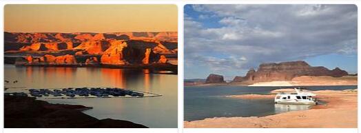
Boat tours from Wahweap Marina
In particular, tickets for boat tours can be purchased at the Wahweap Marina itself, the Chamber of Commerce in Page and the John Wesley Powell Memorial Museum. The “classic” sightseeing tour for European tourists is the trip to the Rainbow Bridge. When making your plans, please note that the half-day tour is only run once a day. If the price is too high for you or if you just want to get an impression of Lake Powell, a canyon trip is also a good choice. The Antelope Canyon is more impressive than the Navajo Canyon, so the Navajo Tapestry Tour is only partially recommendable.
Navajo Bridge
The old and new Navajo Bridges span Marble Canyon. It is one of only seven ways to cross the Colorado River for a total of 1,200 km. Both bridges are similar in appearance and imposingly integrated into the landscape. But technically the bridges differ enormously. The new bridge is technically modern and only looks like the old bridge built in 1927/28, which today only serves as a pedestrian bridge.
Rainbow Bridge National Monument
The Rainbow Bridge National Monument is located in one of the many side canyons. With a height of 88 m and a span of 82 m, it is the largest natural rock arch on earth. Nobody is allowed to walk over it, nobody is allowed to go through the arch of the bridge because the Rainbow Bridge is the Navajo Indians holy. According to legend, some Navajo saved themselves from a flood through the bridge, the only opening of the past to the world of today. According to another legend, warriors saved themselves from enemies through the gigantic opening in the rock. The area is still a Navajo settlement. Traces of their ancestors can be found in the Navajo Canyon, for example. The narrow valley penetrates into the Colorado Plateau over a length of 25 km. At the very end there are around a thousand year old ruins of the Anasazi indigenous people, the disappearance of which is still a mystery today.
The Rainbow Bridge can only be reached by boat or on foot. There are half-day and full-day, but very expensive boat trips from Wahweap Marina and Halls Crossing. An alternative is your own or rented boat, there is an 800 m long path from the boat dock to the bridge. By sea, the bridge is approximately 80 km from Wahweap, Bullfrog or Halls Crossing. Even more arduous is the strenuous footpath that leads through the land of the Navajo Indians and requires a corresponding permit. An off-road vehicle is required to reach the two possible trailheads (Navajo Mountain Trailhead: easy 14 miles, Rainbow Lodge Site Trailhead: easy 13 miles; both trails are unmarked, so good maps are required).
Page
Originally built as accommodation for those working on the construction of the Glen Canyon Dam, the town of Page is now the tourist center of the Glen Canyon NRA and the starting point for most activities in the southern area of Lake Powell. The city offers all tourist infrastructure facilities. The John Wesley Powell Memorial Museum (official website). On display are memorabilia from the pioneer’s Colorado exploration (including a replica of the longboat used) as well as geological and historical finds from the area. Tickets for excursions can also be purchased in the visitor center.
Boat rentals
Motor boats, houseboats, rowing boats and kayaks can be rented (power boats, houseboats, personal watercraft, kayaks). A driving license is also not required for the houseboats.
Lee’s Ferry
A good 15 miles up the river from Glen Canyon Dam, Lees Ferry and the Lonely Dell Ranch Historic District provide a glimpse into pioneering life. By car you can reach Lees Ferry by driving from Page on US 89 south to Bitter Springs, then following Highway 89 A north to the Navajo Bridge (22 km). Lees Ferry is approximately 90 m west of the bridge (total distance from Page = 37 km). Lees Ferry is still the central starting point for rafting tours. From April to October the 5 to 14-day tours through the Grand Canyon start here (this vast landscape officially begins at Lees Ferry) and the 4-day tours over the Paria River end here.
There are some smaller historical buildings just 100 m from the boat ramp. The largest of these is the so-called Lees Ferry Fort, which was built by the Mormons around 1874 to protect against Navajo attacks. The original point of the ferry crossings is about 1.6 km up the river. The ferry was in operation here from 1873 to 1928 and brought Mormon emigrants from Utah to Arizona in particular. See equzhou for overview of Mesa, Arizona. The first settler in the area was John Doyle Lee, who arrived in 1971 and started a ranch. This was in operation until around 1940. The remains of the Lonely Dell Ranch are now the Historic District and can be visited.
Detour to Old Paria
About 65 km northwest of Page branches off the US 89 road to the Paria Movie Set and to Old Paria. This area has been the setting for countless western films and is freely accessible. You can hike through half-dilapidated film sets and the remains of houses and mines from the turn of the century and take in the red and white banded cliffs and badlands.