Safety and Dangers
The typical dangers of a desert landscape lurk here: During the summer season, the sun is more intense and temperatures rise up to 38° C. Humidity is low. It is necessary to eat enough and drink at least 4 liters of water per day. For all activities, you should always take enough water with you and wear loose-fitting, light-colored clothing and a sun hat. Great importance should be attached to sun protection: Apply sunscreen with a high sun protection factor to all exposed areas of the skin. Strenuous activity should be done in the early morning or evening hours.
Activities and Attractions
From May through September, the park offers many special programs including guided hikes, nightly campfire programs in the outdoor amphitheater (near Fruita Campground). Times are posted in the visitor center. Another activity is fruit picking in the historic Fruita orchards. Apples, cherries and other fruits ripen from July to October. Anyone may pick a handful as a snack.
Scenic roads
Major and Minor Routes
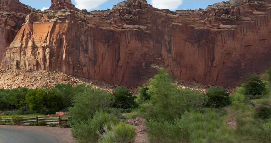
According to usaers, the Waterpocket Fold area can be briefly explored along Utah Highway 24 and the Scenic Drive. Utah Highway 24 is the main east-west route through the park, and the scenic road is a 25-mile gravel road that allows for a short tour of the park. Utah Highway 24 follows the meandering Fremont River through the fold. Rising above the road are the iridescently colored cliffs and domes of Capitol Reef, which give the park its name. This particularly majestic part of the Waterpocket Fold gets its name from the domed white stone domes and its almost impassable ridges. (The pioneers sometimes called these rocks “reefs”).
The scenic road follows the west side of the fold and leads to the Grand Wash and Capitol Gorge, two deep, tortuous, water-carved gorges with sheer walls. Paths along the panoramic road lead to vantage points, secluded gorges, naturally formed stone arches and smooth rock masses. Great views of the Waterpocket Fold area are also available from main and side roads outside the park. One of these sweeping panoramas can be seen along Utah Highway 12 west of the park at an elevation of more than 10,000 feet. Because of their nature, other dusty gravel roads are only suitable for high-clearance 4WDs. Rain and snow may make some roads impassable from time to time.
The Cathedral Valley Loop Tour
Most visitors to Cathedral Valley complete this 95 km (59 mile) loop tour. The route begins at the Ford River 19 km (11.8 miles) east of the visitor center on Highway 24, on Hartnet Road. It runs to The Cathedral Road (aka Caine Wash Road) and then back to Highway 24 west of Caineville (30 km – 18.6 miles – east of the visitor center.)
Thousand Lake Mountain Road
This scenic route offers breathtaking views of the surrounding desert. The dirt road climbs steeply through evergreen forest – from 2,073 m above sea level at the Hartnet/Cathedral (aka Caine Wash)/Polk Creek Road junction – to 2,896 m at Thousand Lake Mountain. From there it leads to 2,134 m on Hwy. 72 down. The Bergstrasse is usually open from mid-June to the end of October. It is closed in winter and spring due to heavy snowfall and muddy conditions.
Hike
Day Hikes
There are 15 day hikes in the Fruita area starting along Utah Highway 24 and the Scenic Drive. These trails offer hikers a variety of options – from easy strolls along easy, level paths – to strenuous hikes with steep climbs over uneven terrain near cliff edges. Some tours lead to stone arches and deep, narrow gorges or great viewpoints. The routes vary from half a kilometer to 16 kilometers. All routes are well signposted from the starting point and along the paths. Trail maps are available at the visitor center and also at this link >>
Backcountry Tours
Capitol Reef National Park offers many hiking opportunities for backpackers. Marked hiking trails lead into narrow, winding gorges and canyons and to spectacular viewpoints high up on the Waterpocket Fold. Popular backcountry hikes in the southern portion of the park include the Upper and Lower Muley Twist Canyons and Halls Creek. Backcountry tours are also available in Cathedral Valley and near Fruita. Before any backcountry tour, it is a good idea to speak to a ranger at the visitor center. They will assist in tailoring the tour to the ability and time available. If you are planning a night hike, you must apply for a free backcountry permit at the visitor center.
Upper Muley Twist Canyon
Highlights of the hike are narrow canyons, sheer plains of rock, large arches and dramatic views from the top of Waterpocket Fold. The canyon offers many opportunities for off-route excursions. It is 3 miles from the Upper Muley Twist Canyon Trailhead to the Strike Valley Overlook Parking Lot. The distance from the Strike Valley Overlook car park to Saddle Arch is 1.7 miles. More details about the tour can be found here >>
Lower Muley Twist Canyon
The highlight of the hike is a deep, narrow, and twisting canyon. More information about this tour >>
Plan Your Visit
Hiking, picnicking, wildlife viewing and walking through the orchards are popular activities in Capitol Reef National Park. Below are some suggestions on how to organize your stay:
If you have two hours
- Drive to the visitor center, learn more and watch the orientation film
- Hike one of the short trails in the Fruita area
- Drive the Scenic Drive (about 90 minutes round trip)
- Visit the Rock Carvings, Historic Schoolhouse, Behunin Cabin (Hwy 24) or Historic Gifford House, Nature Center or Blacksmith Shop (on Scenic Drive)
- Join a guided ranger tour
If you have a whole day
- Hike one of the longer trails
- Join a ranger-led hike or evening program
- Drive through the Cathedral Valley or the Waterpocket District. Check the visitor center for weather conditions and current road conditions.